


Gjør som tusenvis av andre bokelskere
Abonner på vårt nyhetsbrev og få rabatter og inspirasjon til din neste leseopplevelse.
Ved å abonnere godtar du vår personvernerklæring.Du kan når som helst melde deg av våre nyhetsbrev.
Make your trip to Washington, DC extraordinaryA bike ride along the Potomac river. Fine dining in Penn Quarter. Snapping photos of the iconic Capitol Building. There are so many reasons to visit Washington, DC. Whatever your dream trip involves, this DK travel guide is the perfect companion.Our updated guide brings Washington, DC to life, transporting you there like no other travel guide does with expert-led insights, trusted travel advice, detailed breakdowns of all the must-see sights, photographs on practically every page, and our hand-drawn illustrations, which take you inside the city's buildings and neighbourhoods.You'll discover:- our pick of Washington, DC's must-sees and top experiences- beautiful photography and detailed illustrations, taking you to the heart of Washington, DC- the best spots to eat, drink, shop and stay - detailed maps and walks which make navigating the region easy- easy-to-follow itineraries- expert advice: get ready, get around and stay safe- colour-coded chapters to each part of Washington, DC- a lightweight format, so you can take it with you wherever you goWant the best of Washington, DC in your pocket? Try Top 10 Washington, DC.
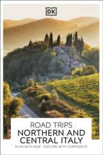
Take a road trip to remember with Road Trips Northern and Central Italy. Hilltop villages, winding Tuscan roads, dramatic alpine passes: Italy is the perfect destination for a road trip to remember. With Road Trips Northern and Central Italy, it's yours to explore.Featuring 25 wonderful drives across the country, and packed with detailed driving instructions and practical information, this easy-to-use guide helps you discover Northern and Central Italy at its best.Inside you'll find:- 25 easy-to-follow scenic driving tours, each lasting one to five days- A laminated pull-out road map of Northern and Central Italy, which helps you navigate with ease- Ways to see more of each area en route, including great viewpoints, delightful detours, walks through historic towns and villages, outdoor activities, and a variety of tours and trips.- Our pick of the best places to stay, eat and shop- Rules of the road, addresses for satnavs, detailed directions for easy navigation, road conditions and parking tips, and useful travel, visa and health informationLooking for more on Northern and Central Italy's culture, history and attractions? Try our DK Italy travel guide.
From Glendalough in the Wicklow mountains to Tipperary's Rock of Cashel and Offaly's Clonmacnoise, from Aghagower in County Mayo to County Dublin's Clondalkin, Round Towers Of Ireland features over forty of these remarkable and intriguing structures.
The world's favourite pocket travel guidesMake the most of your trip to Copenhagen this Top 10 guide. Planning is a breeze with our simple lists of ten, covering the very best that Copenhagen has to offer and ensuring that you don't miss a thing. Best of all, the pocket-friendly format is light and easily portable; the perfect companion while out and about.Inside this guide to Copenhagen, you'll find:- Top 10 lists of Copenhagen's must-sees and must-dos, including visiting the Nationalmuseet, wandering through the gardens of Kongens Have and taking a canal tour- Copenhagen's most interesting areas, with the best places for sightseeing, food and drink, and shopping- Themed lists, including the best outdoor activities, museums, nightlife, local dishes and much more- Brand-new itineraries, perfect for a day trip, a weekend or a week- A laminated pull-out map of Copenhagen, plus five full-colour area mapsDK's Top 10 travel guides have been helping travellers to make the most of their breaks since 2002.Looking for more on Copenhagen's culture, history and attractions? Try our DK Denmark travel guide.
The world's favourite pocket travel guidesMake the most of your trip to Amsterdam with this Top 10 guide. Planning is a breeze with our simple lists of ten, covering the very best that Amsterdam has to offer and ensuring that you don't miss a thing. Best of all, the pocket-friendly format is light and easily portable; the perfect companion while out and about.Inside this guide to Amsterdam, you'll find:- Top 10 lists of Amsterdam's must-sees and must-dos, including visiting the Rijksmuseum, exploring Begijnhof and taking a boat tour of the canals- Amsterdam's most interesting areas, with the best places for sightseeing, food and drink, and shopping- Themed lists, including the best cycle rides, museums, historic buildings, shops and markets, and much more- Brand-new itineraries, perfect for a day trip, a weekend or a week- A laminated pull-out map of Amsterdam, plus eight full-colour area mapsDK's Top 10 travel guides have been helping travellers to make the most of their breaks since 2002.Looking for more on Amsterdam's culture, history and attractions? Try our DK Amsterdam travel guide.
Get to know Disneyland like never before! I Love Disneyland is the ultimate fan guide packed with insider knowledge and fun trivia about all the Park’s iconic rides and attractions—just in time for its 70th anniversary!
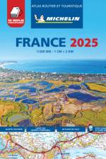
Michelin's France luxurious tourist and motoring atlas is super resistant and easy to use thanks to its fold-out multiflex binding. In addition of Michelin's clear and accurate mapping, this atlas will give you an enhanced view of your journey thanks to its scale 1/200,000. The route planner as well as the time distance charts will help you plan and optimise journey. Michelin's new safety alerts warn you about dangerous driving areas and zones subjet to tighter speed checks. This atlas also includes 40 cities plans with QR codes linking to your smartphone for an easy navigation in urban areas. Information on tourist sights, leisure facilities, scenic routes, as well as service areas will add pleasure and comfort to your journey Michelin's France multiflex tourist and motoring atlas features:- Scale: 1/200,000: for an enhanced view of your journey- Fold flat making it easier to read your journey as you go along- Key to map pages: to quickly access the region of your interest- A complete town index: To easily indentify to destination of your choice- Distance and time chart: to help you plan your trip- 40 city plans with QR Code to guide you through the last few miles of your journey with your smartphone- Michelin's danger alerts: to help you identify zones at risks for drivers and controlled speed areas- Main Road Map for an overview of France's primary road network- 18 pages of European mapping scale 1/3,500,000- 20 pages dedicated to motorway service areas - with facilities available on-site.- In English language: Keys, indexes and information. The atlas is also cross-referenced with the famous Michelin's Green Guide with tourist sights, scenic routes and leisure facilities.
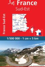
MICHELIN National Map Southeastern France will give you an overall picture of your journey thanks to its clear and accurate mapping scale 1:500.000. Our map will help you easily plan your safe and enjoyable journey in Southeastern France thanks to a comprehensive key, a complete name index as well a clever time & distance chart. Michelin's driving information will help you navigate safely in all circumstances. In addition, MICHELIN National Map Southeastern France is cross-referenced with the famous MICHELIN Green Guide highlighting destinations worth stopping for! With MICHELIN National Maps, find more than just your way!- Up-to-date mapping- A scale adapted to the size of the country- A clear and comprehensive key- Distance and time chart- Place name index- Driving and road safety information- Tourist sights information
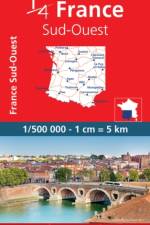
MICHELIN National Map Southwestern France will give you an overall picture of your journey thanks to its clear and accurate mapping scale 1:500.000. Our map will help you easily plan your safe and enjoyable journey in Southeastern France thanks to a comprehensive key, a complete name index as well a clever time & distance chart. Michelin's driving information will help you navigate safely in all circumstances. In addition, MICHELIN National Map Southeastern France is cross-referenced with the famous MICHELIN Green Guide highlighting destinations worth stopping for! With MICHELIN National Maps, find more than just your way!- Up-to-date mapping- A scale adapted to the size of the country- A clear and comprehensive key- Distance and time chart- Place name index- Driving and road safety information- Tourist sights information
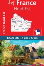
MICHELIN National Map northeastern France will give you an overall picture of your journey thanks to its clear and accurate mapping scale 1:500.000. Our map will help you easily plan your safe and enjoyable journey in northeastern France thanks to a comprehensive key, a complete name index as well a clever time & distance chart. Michelin's driving information will help you navigate safely in all circumstances. In addition, MICHELIN National Map northeastern France is cross-referenced with the famous MICHELIN Green Guide highlighting destinations worth stopping for! With MICHELIN National Maps, find more than just your way!- A scale adapted to the size of the country- A clear and comprehensive key Distance and time chart- Place name index- Driving and road safety information- Tourist sights information
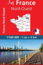
Updated annually, MICHELIN National Map Northwestern France 706 will give you an detailed picture of your journey from Amiens to Brest and La Rochelle to Clermont-Ferrand thanks to its clear and accurate mapping scale 1/500,000. Our map will help you easily plan your safe and enjoyable journey in the southwestern parts of France thanks to a comprehensive key, a complete name index as well a clever time & distance chart. Michelin's driving information will help you navigate safely in all circumstances. Furthermore this map features zoom on major cities and towns as well as QR codes to the complete your journey with ViaMichelin. This map includes tourist sights, scenic route and is cross-referenced with the famous MICHELIN Green Guide highlighting destinations worth stopping for! With MICHELIN National Maps, find more than just your way! MICHELIN NATIONAL MAPS feature:- Up-to-date mapping- A scale adapted to the size of the country- A clear and comprehensive key- Distance and time chart- Place name index at the reverse side of the map- Driving and road safety information- Tourist sights information
Updated annually, the best selling MICHELIN National Map France (map 721) will give you an overall picture of your journey in France thanks to its clear and accurate mapping scale 1/1,000,000. Our map will help you easily plan your safe and enjoyable journey in France thanks to a comprehensive key, a complete name index as well a clever time & distance chart. Michelin's driving information will help you navigate safely in all circumstances. In addition, MICHELIN National Map France is cross-referenced with the famous MICHELIN Green Guide highlighting destinations worth stopping for! With MICHELIN National Maps, find more than just your way!MICHELIN NATIONAL MAPS feature:- Up-to-date mapping- A scale adapted to the size of the country- A clear and comprehensive key- Distance and time chart- Place name index- Driving and road safety information
What do our gardens say about us?Monty Don has spent many years travelling the world, from America to Japan, from Italy and the Adriatic to Spain and the Mediterranean, getting under the skin of a country through its gardens and gardening traditions. In British Gardens, he finally brings his focus to home, journeying from the northern tip of Scotland to the Cornish coast, seeking to understand what our gardens tell us about ourselves as a nation. Encompassing historical gardens and public parks, mountains and seascapes, urban gardens and rural nurseries, glasshouses and community plots, each encounter is another link in a larger story of British identity: marks of ingenuity, eccentricity, and adaptation to changing environments. From Northumbria's Alnwick Gardens and Beatrix Potter's Lake District farmhouse to the rewilded walled garden on the Knepp Estate and the story of Britain's first garden gnome, Monty's account brings in an astonishing range of British experience. Accompanied by a landmark five-part series on BBC2, and illustrated by stunning photography from Monty's long-time collaborator Derry Moore, British Gardens is a definitive, and uniquely British, account of a nation like no other.
Discover 15 of the best short walks around North Perthshire, including Pitlochry, Aberfeldy and Dunkeld. Each walk comes with easy-to-read Ordnance Survey maps, clear route description and lots of images, plus information on local beauty spots and tasty refreshment stops. No challenging terrain or complicated navigation means walks can be enjoyed by everyone.
Abonner på vårt nyhetsbrev og få rabatter og inspirasjon til din neste leseopplevelse.
Ved å abonnere godtar du vår personvernerklæring.